
GREEN VOLCANOES
Green tropical jungle-covered volcanoes standing out of warm blue seas in balmy Trade Winds, surrounded by palm-lined white coral sand beaches and reefs may be the ideal of the tourist trade and the eco-tourist seeking unspoiled tropical rain forest, but they can be a headache for the geologist looking for rocks. In a review of the geology and hazards of the Commonwealth of Dominica, in the center of the Lesser Antilles volcanic arc we encountered this problem. The two volcanoes that make up the northern end of the island – Morne aux Diables in the far north, and to its south Morne Diablotins (1421m the highest point on the island) – are both very green. Exposures in the sea cliffs and along the coastal roads show that both volcanoes are made up of older foundations (3.7 to 1.8 million years for Morne Diablotins and 2.0 to 1.7 million years for Morne aux Diables) that have been deeply dissected by erosion. Both are capped by very young deposits that were probably erupted in the past 100,000 years, which overlie the older deposits on the coasts. But where are the sources of the young deposits inside those green jungle-covered mountains?
We put the problem to our friend Dr. Ian C.F. Stewart of Stewart Geophysical Consultants Pty. Ltd. who has already produced the rather nice topographic images of the Lesser Antillean volcanic islands on this website (see RADAR IMAGES). He did this using the American Shuttle Radar Topography Mission (SRTM) imagery acquired in 2000 which he downloaded. The SRTM data for Dominica is available as a geographic grid of 90-meter cell size and was converted to a UTM grid in Zone 20 using the WGS84 spheroid. Ian produced two new topographic images of Dominica with a pixel size of 50 meters to retain as much detail as possible and the marine area was fenced out using NOAA coastline data. The two topographic images have illumination from the NE and SE to illustrate different topographic features (Figures 1 and 2). For a fuller explanation the reader is referred to the RADAR IMAGES section of this website.
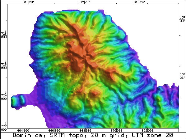
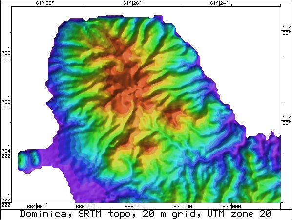
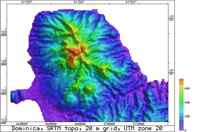
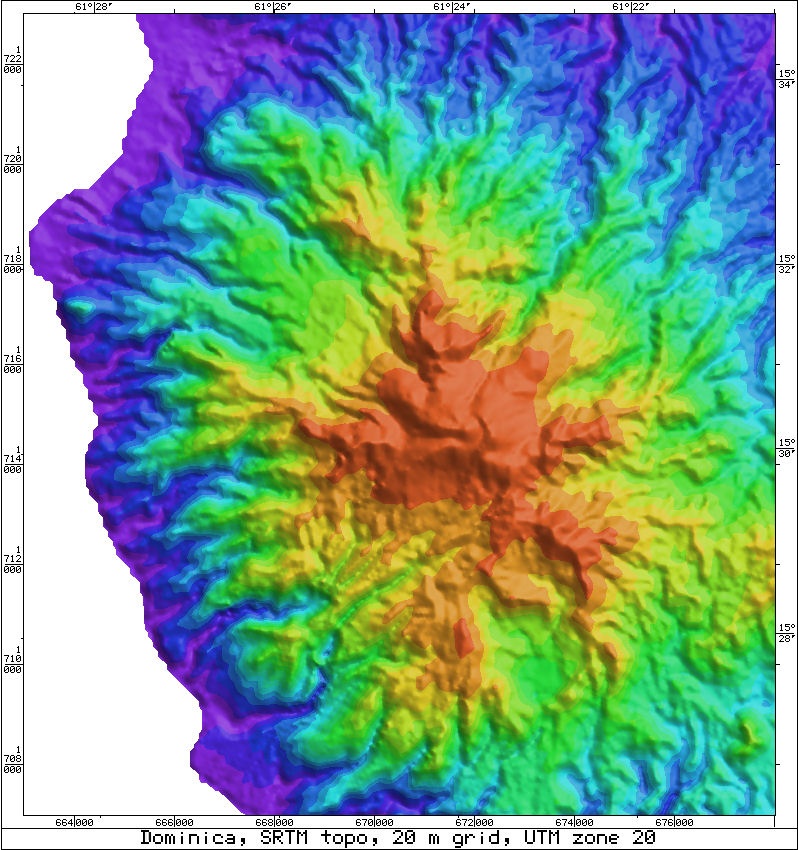
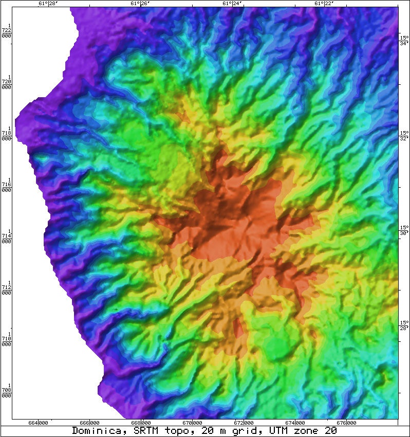
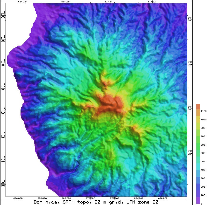
More detailed maps were produced for the Morne aux Diables and Morne Diablotins volcanoes. For these, the data was regridded at a 20 m interval (pixel size). For Morne aux Diables, the maximum height in the grid was 836 m. Two images were produced, one illuminated from the NE and the other from the SE (Figures 3 and 4) to bring out different topographic features. On these images there is an automatic color scale that gives the best color stretch to make full use of the 15 colors. A third image of Morne aux Diables illuminated from the NE (Figure 5), has a fixed color interval of 50 m including a color scale bar. For Morne Diablotins three similar images have been produced (Figures 6, 7 and 8). The images are UTM Zone 20 with a central meridian of 63 degrees W.
Ian also produced two ASTER DEM images of the island. This is a US/Japanese effort that uses optical imagery rather than radar to get the heights, and shows a lot more detail in some areas. In contrast in densely vegetated areas, the SRTM uses tree canopy height for the radar data. The main use of ASTER is for its multispectral imagery and it is heavily used by the exploration industry for mapping different lithologies as its resolution is much better than LANDSAT, both in pixel size and number of bands. The ASTER DEM images for Dominica have a 20 m grid. Figure 9 makes use of the full color range, whereas Figure 10 has a 100m color interval. Both images show peaks to 5,700 m in the data as red spots. These are clouds which could not be removed from the data in the original processing, although multiple images are normally used to give the final DEM.
We give now a summary of how useful the 10 images were in resolving the geological features of the superstructures of the two green volcanoes.
Figures 1 and 2. These whole-island SRTM images with NE and SE illumination clearly show the deeply-eroded nature of most of Dominica. Maximum erosion is in the oldest Miocene centers in the middle east side of the island. Although deeply dissected the Miocene centers remain distinct with the highest peaks showing a radial arrangement of narrow ridges around them. Most of the island shows deep erosion of the upper Pliocene to lower Pleistocene volcanoes. In contrast are the smooth surfaces (lacking erosion) of the upper Pleistocene to Holocene Pelean domes on Morne aux Diables, Morne Diablotins, Trois Pitons, Micotrin and Morne Anglais. Small explosion craters can be seen in the tops of the Trois Pitons and Micotrin domes. The sector collapse scar of the Soufriere depression in the southwest part of the island is also clear. To the west of Trios Pitons and Micotrin, the north-south scarp of the west wall of the Central Graben is also distinct.
Figures 3 to 5. The Morne aux Diables volcano is clearly illustrated with radial deeply eroded valleys cut into the 1.7 million year old pyroclastic deposits. The highest part of the volcano can be seen to have three smooth sided Pelean domes. A narrow ridge extending south from them is an eroded remnant of the older part of the volcano. The lower to upper Pleistocene volcano died around 1.7 million years ago and was either regenerated or overlain by young upper Pliestocene centers some 1.5 million years later. Tongues of young valley-fill block and ash flow deposits radiate from the young Pelean domes. The colour scheme of Figure 5 most clearly brings out the details of the top of this volcano.
Figures 6 to 8. These images were particularly valuable in interpreting the superstructure of Morne Diablotins stratovolcano. The deeply eroded stratovolcano formed between 3.7 and 1.8 million years ago. However the coastal exposures reveal the presence on top of the eroded surface of tongues of ignimbrite and young unconsolidated block and ash flow deposits that may have formed during the past 100,000 years. The ignimbrites would have been erupted from an open crater by Plinian activity and the block and ash flow deposits from dome-building Pelean activity. The images, especially Figure 8, show the top of Morne Diablotins to be a pair of nested smooth-surfaced Pelean domes. A similar pair of domes are present on Mt. Pelee Martinique. They formed when the 1902 dome was partially cored out by an explosion crater in which the 1929 dome formed. Most interesting is the presence of several narrow steep-sided ridges radiating away from the domes. These also have peaks on them. These outer peaks and the ridges are interpreted as eroded remnants of the 3.7 to 1.8 million year stratovolcano. This stratovolcano would have been higher than the present Morne Diablotins. A crater must have formed that lies inside the ring of outer peaks of older material. This would have been the vent for the Plinian activity that produced the fans of ignimbrite that radiate around the flanks of Morne Diablotins. The fans are arranged such that they have been channelled between the outer peak remnants of the old stratovolcano before the central crater became filled by younger products of Pelean activity.
Figures 9 and 10. These ASTER DEM image of Dominica when compared with the SRT images of Figures 1 and 2 shows much the same detail as the SRTM images (Figs 1 and 2). The red spots are anomalous peaks caused by cloud are impossible structures and especially obvious in the color scheme of Figure 10. However the ASTER DEM images of the superstructure of Morne Diablotins lack the detail of the SRTM images and the interpretation made above could not be made using only the ASTER DEM images.
For more information contact:
Dr. Ian C.F. Stewart
Stewart Geophysical Consultants Pty. Ltd.
Email: stewgeop@senet.com.au